Geographically the Southern Caucasus is a territory of the Caucasian isthmus south from the Main Caucasian Range and includes 3
countries - Armenia, Azerbaijan and Georgia- with a total area of 186,1 square kilometers.
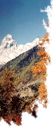
A jet plane can cross the Southern Caucasus in less than one hour. During that short time the absorbed spectator will see a kaleidoscopic
of views with snow-covered peaks, flourishing plains, forested hills, azure seas, humid subtropic forests, sun-burnt semi-deserts, emerald
alpine meadows, thorny bushes, fertile highlind plateaus, and huge fields covered with rocks and stones. We will see large buzzing cities,
stacks of industrial giants, innumerous derricks, plantations of tea, lemon, bamboo, eucaliptus. The vineyards and gardens climb up the hills
and mountain terraces; fields are painted in different colours by wheat, corn, rice, cotton, and tobacco; herds of sheep drift by the highland
and steppe pastures.
A long and warm summer, plenty of beaches, hundreds of mineral springs, fresh mountain air, picturesque landscapes and an abundance of
historical monuments make the Southern Caucasus an attractive region for tourism.
Geological Formation and Terrain
The Southern Caucasus's mountains have a deep and diverse influence on the formation of the natural environment, the conditions of
peoples' lives and economical development.
The Southern Caucasus are totally mountainous and its lowlands (not to speak of meadows and plains) are connected to surrounding
mountains both by geological origin and through the character of contemporary natural processes. Wherever you've been, even if it's the
Kolchida or the Kur-Araxes lowland, a clearly visible chain of snowy peaks on the horizon will remind you of where you are. The climate, rivers
and vegetation peculiarities are strictly connected to the mountainous terrain of the Southern Caucasus. The mountains define the altitude
zonality of the landscapes and the consequent diversity of natural conditions.
Despite of separated and complicated character of Southern Caucasus terrain there are few definite natural entities here.
A gigantic mountain system of the Caucasus Range extends for 1500 kilometers and cuts into the Southern Caucasus with its branches
and spurs. The greater Caucasus mountains are higher than the Alps - the highest peak is Elbrus (5633m.), Kazbek (5047m.), Dychtau
(5198m.), Shkhara (5058m.), Rustaveli Peak (4960m.), Tetnuld (4858m.) and Ushba (4695m.).
The southern part of Caucasus occupies the northeast regions of the volcanic Armenian Plateau bordered by the Lesser Caucasus Range
and the Talish Mounts. There is a plain zone between the Greater and Lesser Caucasus - the Kolkhida lowland on the west, the Kartli Plains
in the middle, and the Kur-Araxes lowland on the east.
There are high ridges detaching to the southwest from the Caucasus Range: Gagra, Bzyba, Kodori, Svaneti, Racias, Likh (the latter
connects the Greater and Lesser Caucasus), as well as the Kartli and Kakheti Ridges detaching to the east.
The southern part is situated on the vast Armenian Plateau and is typical continental volcanic highland characterized by volcanic relief. High
(1500-2000m.) and relatively plain lava plateaus are surrounded by the Samsara, Javakheti, Geghama, Vardenis, Ayotsdzor, and Zangezur
Ridges, as well as separate volcanic massives (the largest is 4090m. high, Mount Aragats). The high altitude of these plateaus lessens the
contracts with the height of ridges and thus less considerable and impressing. The ridges separate the highland into different plateaus
(Javakheti, Shirak, Karabagh, etc) and relatively low hollows (the Ararat and Nakhichevan plains and the Sevan basin with a lake of the same
name).
Climate
The geographical location of the Southern Caucasus, at the border where the humid Mediterranean and dry continental air masses meet,
complicated mountainous terrain, and other factors shape the wide diversity of the climate. The Southern Caucasus is a home for various
climate zones starting with everlasting snowcaps and glaciers to warm humid subtropical forests and humid semi-desert steppes.
The Greater Caucasus on the north is an obstacle for cold northern air masses to meet the western and central areas of the Southern
Caucasus (the Kolchidan lowlands and the Kura bowl), thus raising its average temperatures.
The Kolchidan lowlands - the warm, humid, subtropical forests of the Black Sea shore - with its unique soil and climate has a special place in
the biosystem of the region. That favorable combination of soil and climate allows a growing wide range of thermophilic and water-resistant
subtropical plants. Even during the coldest period of January the average temperature is 4°C-5°C with an annual precipitation
reaching 2700-3000mm in the Batumi area.
The Lenkoran lowlands at the shore of the Caspian Sea have similar features and a subtropical plants exist here, to a lesser extent. In
general the eastern part of the Southern Caucasus is more arid, and the annual precipitation decreases from 500-600mm in Tbilisi to
200mm in Baku. Summers are hot and long with average temperatures of 27°-28°C .
The major part of the Armenian Highland has a dry, continental climate with warm temperatures(18°C-20°C), and in the Araxes
Lowlands hot summers (average 25°C-26°C) and cold winters (from -5°C in plains to -13°C in the alpine meadows). The difference
from lowlands is also demonstrated by the stable snow cover at the highland plateaus, and at some the most isolated plateaus the
temperature can drop to -40°C. Due to the crossed terrain the annual precipitation varies from 700-800mm at some mountain
slopes to 250-300mm in Ararat Valley.
The climate in the Lesser Caucasus is definitely milder, especially at the slopes descending to the Kolchidean and Kura lowlands. Winter
here is cool, summer is warm and humidity is relatively high.
The Greater Caucasus highland is peculiar with its relatively cold winters (-6°C-10°C and in ridge areas to -14°C-17°C) and moderately
warm summers (10 above Celsius at altitudes of 1700-2000m and 0°C-4°C at altitudes of 3500-4000m). Such climate is
explained by eternal snocap belts with their lower level at attitudes of 2700-2900m in the west and 3000-3500m in the eastern part of the
Greater Caucasus.